By the Monterosa Booking team, with the support of IFMGA mountain guides from Monte Rosa
In short
Punta Dufour, at 4,634 metres, is the highest summit of Monte Rosa, the highest point in Switzerland and the second highest mountain in the Alps after Mont Blanc. But reducing it to a number would mean telling only a small part of its story. The Dufour is a complex mountain: less immediate than the Matterhorn, less easy to recognise at first glance, but deeply connected to the history of alpine exploration, cartography, mountain guides and the great faces of Monte Rosa.
Punta Dufour is different. It does not reveal itself so simply. It does not always appear as a separate, obvious summit that can be pointed out with one finger. It belongs to a vast massif made of ridges, glaciers, faces and peaks rising above 4,000 metres. From a distance, it can almost blend into the rest of Monte Rosa.
To truly understand it, you need to change your point of view: look at it from Macugnaga, follow its outline from the Swiss side, imagine it within the great glacial system that surrounds it.
This is exactly its strength. The Dufour does not tell the story of one mountain alone. It tells the story of Monte Rosa in its widest form: not an isolated peak, but an entire world of ice, rock, ridges and valleys.
The highest summit of Monte Rosa
Punta Dufour reaches 4,634 metres. It is the highest summit of the Monte Rosa massif, the highest point in Switzerland and the highest point of the Pennine Alps.
It lies in the Canton of Valais, on the Swiss side of Monte Rosa, close to the Italian border. To the north, it is surrounded by the great glaciers descending towards Zermatt. To the south-east, it drops towards Macugnaga through the great east face of Monte Rosa.
And here, the mountain changes completely.
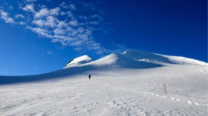
Seen from the Swiss side, the Dufour belongs to a wide glacial landscape. It is normally climbed from the Monte Rosa Hütte, crossing glaciers and continuing towards a final ridge where snow, ice and rock alternate.
Seen from Macugnaga, however, the mountain becomes vertical, severe and almost Himalayan in scale. The east face of Monte Rosa rises for more than 2,000 metres above the head of the Anzasca Valley, with couloirs, rock spurs, seracs and hanging glaciers.
It is not just any face. It is one of the most impressive settings in the Alps.
A mountain that was difficult to read
Before it could be climbed, Punta Dufour first had to be understood.
Today we are used to accurate maps, GPS tracks, route descriptions, photographs, weather forecasts and satellite images. At the beginning of the nineteenth century, none of this existed. Monte Rosa was still a territory to be interpreted. Its summits were numerous, close together and often confused with one another. Understanding which point was the highest was not immediate.
The history of the Dufour, in fact, does not begin directly on its summit. It begins with the exploration of the massif.
In 1801, Pietro Giordani, a doctor from Alagna, reached alone the summit that now bears his name: Punta Giordani, 4,046 metres. It was one of the first major high-altitude explorations of Monte Rosa from the Italian side. He climbed with equipment and knowledge far removed from what we have today, and was forced to spend a night at altitude, sheltering in a cavity in the ice.
In 1819, the brothers Joseph and Johann Niklaus Vincent, originally from Gressoney, reached the Piramide Vincent. The following year, an expedition with Joseph Zumstein reached the summit now known as Punta Zumstein, at 4,563 metres.
Each ascent added another piece to the understanding of Monte Rosa. But the highest point was still beyond.
This is an important part of the story: Monte Rosa was not understood in a single gesture. It was read little by little, from different valleys, by different generations, by people who climbed without having a complete map of what they were looking for.
The first ascent of 1855
The western summit, today known as Punta Dufour, was first reached on 1 August 1855.
The ascent started from the Zermatt side and came after decades of attempts and exploration. It was not only the reaching of an altitude. It was the moment when the highest point of Monte Rosa was finally reached, identified and entered into the history of alpine climbing.
Thinking about that ascent today requires some effort.
There was no modern equipment, no communication as we know it, no detailed bulletins, no organised rescue system in the modern sense. Every decision carried a much larger margin of uncertainty.
Climbing a mountain in those years meant truly exploring. Not only following a route, but understanding whether that route existed at all.
Why is it called Punta Dufour?
Before taking its current name, the mountain was known by names such as Höchste Spitze, meaning “highest summit”, or Gornerhorn.
In 1863, it was named after Guillaume-Henri Dufour, a Swiss general, engineer and cartographer. Dufour was not the first person to climb the mountain. His name is connected to another way of knowing the Alps: measuring them, representing them and making them readable.
Dufour directed the creation of the first major modern topographic map of Switzerland, known as the Dufour Map.
This is an interesting detail, because it links the mountain not only to the history of alpinism, but also to the history of territorial knowledge. Before a summit can be described, it must first be placed on a map. Before it can be climbed with awareness, its shapes, faces, borders, altitudes and relationships with the surrounding landscape must be understood.
The name Punta Dufour reminds us of exactly this: a mountain is not only a place to reach. It is also a place to understand.
Not simply “one more summit”
Those who know Capanna Margherita may think of the Dufour as a natural continuation of Monte Rosa. In reality, it is not.
Punta Dufour is not a slightly higher version of the Margherita. It is a different objective: more technical, longer, more exposed and more demanding.
It requires experience using crampons and an ice axe, the ability to move roped together, confidence on exposed ridges, familiarity with rock passages and good management of fatigue at altitude. The descent, as often happens in high mountains, is a central part of the day and cannot be considered a detail.
It is chosen after assessing experience, preparation and real conditions.
The guides’ view: what to know before thinking about the Dufour
We asked some Monte Rosa mountain guides what should be considered before thinking about Punta Dufour. Their answers all point in the same direction: the Dufour is not a climb to choose simply because it is the highest summit of the massif, nor because it appears close to Capanna Margherita. It is a different objective: technical, exposed and something to prepare for carefully.
Ioris Turini: real mountaineering skills are necessary
According to Ioris Turini, Punta Dufour requires real mountaineering skills. It is not enough to be fit or to have already walked on a glacier.
Anyone thinking about the Dufour should be able to climb safely, both up and down, on second- and third-grade passages, wearing mountaineering boots. It is important to already have experience on rocky ridges or mixed terrain, with or without crampons, and to be able to move with clarity when the terrain becomes more technical.
The Dufour cannot be underestimated because, in the event of a retreat, the route still requires significant physical and technical commitment. Turning back is not always simple: even the decision to retreat, on a mountain like this, must be managed with experience, energy and attention.
Renzo Recanzone: it is not the next step after the Margherita
Renzo Recanzone highlights one point above all: Punta Dufour should not be considered simply “the next step” after Capanna Margherita.
Capanna Margherita is a long and tiring ascent, but from a technical point of view it remains mainly a glacier walk. You move at a steady rhythm, one step after another, following the pace of the rope team.
Punta Dufour is something else. The Dufour can present hard snow, ice, rocky sections or mixed terrain. In some conditions, you may need to move with crampons on rock, or on rock lightly covered with snow: situations that require habit, precision and a calm mind.
The most common mistake is to think that, because Punta Dufour is close to Capanna Margherita and belongs to the same massif, it is a similar climb.
The Dufour should not be chosen just because it is there, close and visible. It should be chosen when you have the right skills, the right experience and the ability to move safely on technical and exposed terrain.
Andrea Tamilla: a technically complete ascent
Andrea Tamilla describes Punta Dufour as a technically complex and complete ascent, despite its proximity to summits of the massif that are considered more accessible, such as Punta Gnifetti and Punta Zumstein.
The Dufour requires you to deal with airy snow ridges, steep and often icy sections, both on the ascent and on the descent. Added to this are sections of rock and mixed terrain, most often climbed with crampons on your feet. All of this takes place above 4,400 metres, where even a simple movement requires more energy, more attention and more clarity.
For Andrea, these elements make the Dufour a climb suited to mountaineers with well-established foundations. It is not the terrain on which to improvise technical skills.
As preparatory experiences, he mentions routes such as the Cresta del Soldato to the Vincent, the Sella Ridge on Lyskamm, or the Breithorn traverse: itineraries that help build confidence with ridges, exposure, mixed terrain and altitude management.
Filippo Laurora: do not skip the steps
Filippo Laurora focuses on technical preparation. Punta Dufour is difficult precisely because it requires familiarity with mixed terrain, rock, balance and ridge routes.
After Capanna Margherita, the most sensible next step is not always to aim immediately for the Dufour. For those who want to keep progressing without choosing an objective that is too demanding too soon, it may be better to select a more gradual goal. If the aim is to start experiencing a real ridge, Castore can be an interesting step, always depending on level, conditions and personal progression.
According to Filippo, underestimating a climb means approaching it with too much confidence, without preparing technically and by skipping the necessary stages of mountaineering growth.
The Dufour, on the other hand, requires exactly the opposite: patience, progression and preparation built over time.
Do you want to climb towards Punta Dufour?
Punta Dufour become a project, however. A project to build over time, assessing experience, training, confidence with crampons and ice axe, the ability to move on exposed ridges and familiarity with long days at altitude.
If you dream of Punta Dufour, write to us to organise a technical ascent on Monte Rosa with an IFMGA mountain guide.
Useful resources